
Yellowstone National Park Abiotic Features
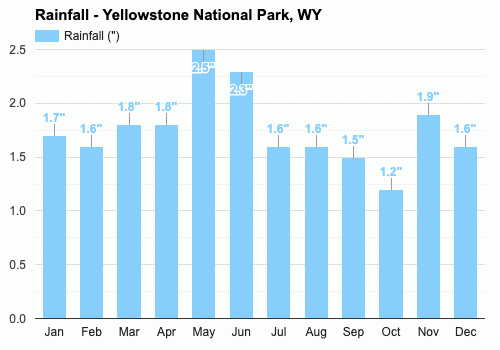
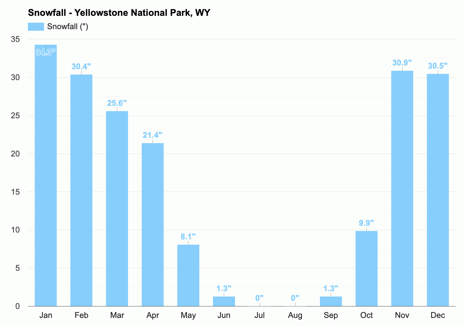
Rainfall and snowfall
The annual precipitaion in Yellowstone National Park is shown in the chart (lower left) and the snowfall (lower right). The park received the most rainfall in May, having 2.5 mm with the average precipitation of around 1.76 mm over the year. The annual precipitation amounts vary with the location and elevation. The lowest being in the north (about 10 inches [250 mm]) and the highest on the western slopes of the northern Teton foothills (about 80 inches [2,000 mm]). As for snowfall, the most amount of snowfall was in winter, particularly in January with a total of 34.3 mm. The park experienced 0 mm snowfall in the months of July and August which are the summer months. The snowfall slowly starts to increase in the Autumn (or Fall) months of September, October and November. Snowfall is heavy in most areas of the park but is heaviest at higher elevations.
Temperature
The temperatures in Yellowstone National Park vary for each season. In the summer months, the average temperature is around 76°F (around 24.4°C) while in the winter months, the temperatures can drop to an average of 31°F (around -1°C). The annual temperature average 52.8°F (around 11.5°C).

climate
The climate at Yellowstone National Park is described as cool and continental. As Yellowstone has a large area, it has varied topography. This causes the weather conditions at different locations to vary widely, the north-central portion of park having wetter summers and drier winters than the rest.
Topographical and physical features
Other physical features include the park's scenic lakes, the largest being Yellowstone Lake, the highest mountain lake of its size in North America which has a surface area of 132 square miles (342 square km) and is elevated at a height of 7,730 feet (2,356 metres). The park also features Yellowstone River's Yellowstone Falls located in the north-central part of the park, with two majestic cascades, the Upper Falls, with a drop of 114 feet (35 metres), and the Lower Falls, with a drop of 308 feet (94 metres). The river has also carved a gorge 19 miles (30 km) long, between 800 and 1,200 feet (240 and 370 metres) deep, and up to 4,000 feet (1,200 metres) wide which was named Grand Canyon of the Yellowstone. The walls of the canyon are sculpted from volcanic rock and are brilliantly coloured in hues of red, pink, yellow, buff, lavender, and white.

The Grand Canyon of the Yellowstone
Out of the park's more than 300 geysers, the most famous is Old Faithful, in west-central Yellowstone which erupts frequently, roughly every 90 minutes. Other geysers include Giantess Geyser, with a two to six-month wait between eruptions, Morning Glory Pool, to the northwest, Excelsior Geyser, which rarely erupts (but discharges thousands of gallons of boiling water per minute), and the Fountain Paint Pots with pink, plopping mud geysers, fumaroles, and a blue hot-spring pool. A majority of these hydrothermal features are located in the western portion of the park, (between Old Faithful and Mammoth Hot Springs which is 80 km to the north). These concentrations are called the Upper Geyser, Midway Geyser, and Lower Geyser basins that extend northward for about 16 km from Old Faithful.

Fountain Paint Pot
Between the southern hydrothermal area and Mammoth Hot Springs, Norris Geyser Basin is noted for having some of the hottest and most acidic hydrothermal features in the park. This includes Steamboat Geyser, which can throw water to heights of 90 metres and is the world’s highest-erupting geyser. Mammoth Hot Springs consists of a hillside composed of travertine or calcium carbonate, deposited by dozens of hot springs. Multicoloured Minerva Terrace and Angel Terrace are among the formations which consists of dazzling white rock that is tinted by microorganisms on the rock.

Travertine terraces at Mammoth Hot Springs

Pitchstone Plateau South-West of Yellowstone National Park
Soils

Teton Mountain Range, south of Yellowstone National Park
The centre of Yellowstone National Park is a volcanic plateau between 7,000 and 8,500 feet (2133.6m- 2590.8m) above sea level and in the south, east, north, and northwest are mountain ranges with culminating peaks and ridges rising from 2,000 to 4,000 feet. Examples of these ranges include the Gallatin Range in the northwest, the Absaroka Range in the east and the Teton Range along the park’s southwestern boundary.

Eagle Peak in the Absaroka Range, the highest point in Yellowstone National Park, northwestern Wyoming, U.S.

Yellowstone Lake
Yellowstone National Park is also famous for its 10,000 hydrothermal features which make up roughly half of all those known in the world. The Yellowstone region is located on a deeply fractured crust which allows groundwater to seep down to where it makes contact with the magma. The mineral-rich water then becomes superheated and returns to the surface as steam vents, fumaroles, colourful hot pools, mud cauldrons, paint pots, hot springs and terraces, hot rivers, and geysers.
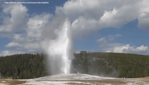
Old Faithful Eruption
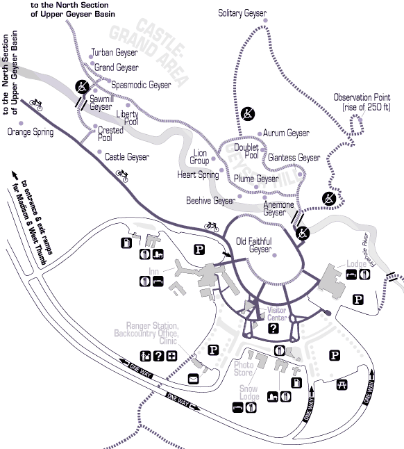
Map of Geysers at Yellowstone National Park
The Yellowstone Caldera is Yellowstone National Park's volcanic caldera. Classified as a supervolcano, the caldera is located in the northwest corner of Wyoming. The last eruption was approximately 70,000 years ago. The Yellowstone Caldera has experienced three large explosions, at 2.08, 1.3, and 0.631 million years ago. This comes out to an average of about 725,000 years between eruptions, the largest of the flows creating the Pitchstone Plateau in the south-west of the park. Another eruption at Yellowstone is possible, but scientists are not convinced it will happen. This is because the rhyolite magma chamber beneath the caldera is only 5-15% molten, so it is unclear if there is even enough magma underneath the caldera to feed an eruption. If the caldera were to erupt, its effects would be worldwide. A giant eruption would have regional impacts such as falling ash and short-term (years to decades) changes to global climate. Pyroclastic flows could effect surrounding states such as Montana, Idaho, and Wyomingwhich are closest to Yellowstone and the rest of the United States would be impacted by falling ash

Yellowstone Caldera, Yellowstone National Park's volcanic caldera
The soils in Yellowstone National Park, which are referred to as 'The Yellowstone Series' consists of shallow drained soils that formed from colluvium and residuum which weathered from basalt and other igneous and volcanic rock types. These soils are found on summits and shoulder slopes of mountains.
The following information sourced from: National Cooperative Soil Survey U.S.A.
TAXONOMIC CLASS: Medial-skeletal, ferrihydritic Lithic Haplocryands
TYPICAL PEDON: Yellowstone stony medial loam, woodland. (Colors are for moist soil unless otherwise noted.)
Oi--0 to 1 inch; slightly decomposed litter of leaves, needles, bark, and wood.
A--1 to 6 inches; dark brown (10YR 3/3) stony medial loam; brown (10YR 4/3) dry; moderate fine granular structure; friable, nonsticky and nonplastic; weakly smeary; many roots; many fine irregular pores; 30% angular gravel and stones; very strongly acid (pH 5.0); clear smooth boundary. (3 to 10 inches thick)
AC--6 to 13 inches; dark brown (10YR 3/3) very stony medial sandy loam; brown (10YR 4/3) dry; weak medium subangular blocky structure; very friable, nonsticky and nonplastic; weakly smeary; many roots; many fine irregular pores; 50% angular gravel and stones; very strongly acid (pH 4.8); clear smooth boundary. (0 to 9 inches thick)
C--13 to 19 inches; brown (10YR 4/3) extremely stony medial sandy loam; pale brown (10YR 6/3) dry; massive; very friable, nonsticky and nonplastic; weakly smeary; many roots; 80% angular gravel and stones; very strongly acid (pH 4.6); abrupt irregular boundary. (0 to 10 inches thick)
R--19 inches; basalt.

Major soil types forests inhabit in Yellowstone National Park


northern lights
The Aurora Borealis, commonly referred to as the Northern Lights, are natural light displays in the sky, predominantly seen in high-latitude regions. They are the result of disturbances in the magnetosphere caused by solar wind. The Northern Lights are rarely seen at Yellowstone National Park but can be slightly visible on very clear nights but are still very faint.
Ivywild family: These soils have ochric epipedons and are greater than 100 cm deep. They are medium or moderately coarse textured and form under forests in glacial till.
0-7 cm: dark brown (10YR 3/3) loam; very strongly acidic, with pH level of 5.0
7-21 cm: dark brown (10YR 4/3) gravelly loam; strongly acidic with pH level of 5.5
21- 100 cm: dark brown (10YR 4/3) extremely cobbly, coarse, sandy loam strongly acidic with pH level of 5.5
Jugson family: These soils have umbric epipedons and are greater than 100 cm deep. They are moderately coarse textured and they also form under forests in glacial till.
0-13 cm: very greyish dark brown (10YR 3/2) loam; very strongly acid, with pH level of 5.4
13-30 cm: dark brown (10YR 3/3) gravelly sandy loam; moderately acidic with pH level of 5.8
30-100 cm: dark grey (10YR 4/1) very gravelly loamy sand moderately acidic with pH level of 5.8
Cryaquepts: These soils have ochric epipedons and are greater than 100 cm deep. They have aquic conditions during the growing season. They are medium to coarse textured and are found under the wet forest habitat types.
4-0 cm: litter layer
0-9 cm: black (10YR 2/1) silt loam, strongly acidic with pH level of 5.2
9-42 cm: very dark grey (10YR 3/1) and black (10YR 2/1) silt and silt loam and moderately acidic, with a pH level of 5.6-5.9
42-100 cm: dark grey (10YR 4/1) very gravelly sand, moderately acidic with a pH level of 5.9

Aurora Borealis, Wyoming side of Yellowstone National Park